
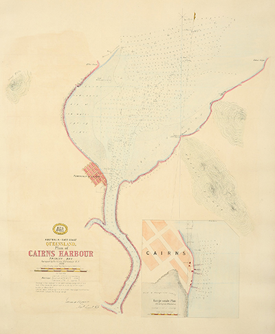
Plan of Cairns Harbour
Dublin Core
Title
Identifier
Description
Hand coloured lithograph titled:
'Plan of Cairns Harbour Trinity Bay Surveyed by Navg. Liet. E.R.Connor. R.N.'
Also titled:
'Australia - East Coast, Queensland : plan of Cairns Harbour, Trinity Bay, 1878'
A hydrographic chart giving soundings in feet, reduced to low water ordinary spring tides, or to a level 12 feet below the datum mark ^ on the top of the largest boulder on Bessie Point. Coverage extends seaward of the mouth of the Barron River, across to False Cape and downstream beyond Cairns. Includes costal profile.
Inset: Cairns large scale plan shewing the wharves etc. Soundings in feet at L.W. springs.
Creator
Subject
Cairns Harbour (Qld.) -- Navigation -- Maps;
Cartography;
Connor, Edward Richard;
Mapping;
Nautical charts -- Queensland -- Cairns Harbour.
Royal Navy -- Hydrographic Survey;
Queensland. Department of Harbours and Marine;
Queensland--History--Maps;
Nautical charts -- Queensland -- Cairns Harbour.
Surveying & Surveyors;
Surveyors -- Queensland -- History -- 19th century.
Date
Source
Although the port of Cairns was declared in October 1876, the harbour was not surveyed for shipping until 1878. Until then, buoys were used to guide ships from the Fairway buoy (marking the channel entrance) through the channel towards Trinity Inlet, with a lantern on shore serving as a leading light at night.
Publisher
Contributor
Edward Richard Connor (11 February 1846, Blean, Kent-1903)
Connor joined the Royal Navy as a Master’s Assistant in 1861 at the age of 15. He was promoted to 2nd Master in 1866, and a Navigating Lieutenant in September 1872. He served on H.M.S. Nassau from April 1866 to August 1869, which undertook a hydrographic survey in the Mediterranean and then on the east coast of Africa suppressing the slave trade.
Between 1870 and 1879 he served in Australia on H.M.S. Clio, H.M.S. Pearl and H.M.S. Wolverene surveying the east coast of Queensland coast and the Torres Strait.
Format
Scale 4 inches to a Nautical miles (1:18,153)
Type
Coverage
Old Smithfield township, Barron QLD 4871
Colonial Queensland
1870s
Rights
Original item held at the Department of Natural Resources, Mines and Energy, Queensland Government, Brisbane.
Embed
Copy the code below into your web page
Item Relations
| This Item | is similar to | Item: Map C153.012, Cairns and the Barron River |
| This Item | is similar to | Item: Map C153.017, Tracks to the Hodgkinson Goldfields |