
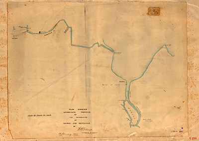
Map C153.012, Cairns and the Barron River
Dublin Core
Title
Map C153.012, Cairns and the Barron River
Identifier
Map C153.012
Description
Plan showing approximate positions of the township of Cairns and Smithfield by F.H. Warner, Licensed Surveyor, dated 10 January 1877.
Map shows Cairns, Dickson Inlet, False Cape, Barron River, Casuarina Pt (which was the mouth of the Barron River in 1877), Davidson Creek (now Freshwater Creek), Smithfield, Red Peak, the Douglas Track and Smith's Track.
Creator
Frederick Horatio Warner [Queensland Land Surveyor]
Subject
Cadastral maps;
Cartography;
Mapping;
Queensland. Department of Mapping & Surveying;
Queensland--History--Maps;
Surveying & Surveyors;
Surveying--Australia--Queensland;
Surveyors -- Queensland -- History -- 19th century;
Warner, Frederick Horatio.
Cartography;
Mapping;
Queensland. Department of Mapping & Surveying;
Queensland--History--Maps;
Surveying & Surveyors;
Surveying--Australia--Queensland;
Surveyors -- Queensland -- History -- 19th century;
Warner, Frederick Horatio.
Date
10 January 1877
Publisher
Department of Natural Resources, Mines and Energy, Queensland Government
Format
Paper map
Scale 40 chains to an inch (1:31,680)
Scale 40 chains to an inch (1:31,680)
Type
Still Image
Coverage
165138S1454201E
Old Smithfield township, Barron QLD 4871
Colonial Queensland
1870s
Old Smithfield township, Barron QLD 4871
Colonial Queensland
1870s
Rights
This page © 2021 oldsmithfield.com
Original item held at the Department of Natural Resources, Mines and Energy, Queensland Government, Brisbane.
Original item held at the Department of Natural Resources, Mines and Energy, Queensland Government, Brisbane.
Relation
See also:

Map C153.017, Tracks to the Hodgkinson Goldfields
Tracing of a rough sketch of the Hodgkinson goldfields tracks leading to the coast, Sd. [sketched by] W.M. Mowbray, 31 January 1878.
Embed
Copy the code below into your web page
Item Relations
| This Item | is similar to | Item: Map C153.017, Tracks to the Hodgkinson Goldfields |
| Item: Plan of Cairns Harbour | is similar to | This Item |
Collection
Citation
Frederick Horatio Warner [Queensland Land Surveyor], “Map C153.012, Cairns and the Barron River,” 10 January 1877, Map C153.012, Department of Natural Resources, Mines and Energy, Queensland Government, https://www.oldsmithfield.com/omeka/items/show/20.